Aerial Photography: 9 Types You Should Know for Stunning Shots
Is your business struggling to stand out? Without aerial photography, you could miss a chance to showcase projects in a fresh way. Ground-level images just can’t capture the unique angles aerial shots provide. Photos like oblique and vertical views reveal property boundaries and highlight key features. These perspectives make projects memorable. Digital and color-infrared imagery add even more impact. Shots from airplane platforms or aerial drones capture wide views and fine details. These sharp digital images enhance your marketing and tell engaging stories.
Want to know the difference between satellite and aerial imagery? Read on to explore how professional aerial photography can transform your business.
What is Aerial Photography?
Aerial photography is the practice of capturing images from above. It uses drones, aircraft, or satellites to take air photos over large or difficult locations. These images show real distance and precise measurements. This technique highlights key elements that ground-level shots can’t capture.
Aerial photography is essential in fields like real estate, construction, and environmental planning. It provides valuable insights for better decisions and efficient project planning.
What are The Different Types of Aerial Photography?
Aerial photography offers a unique view of the world from above. Different types of aerial photography serve various purposes. Each one captures images with distinct angles, altitudes, and techniques.
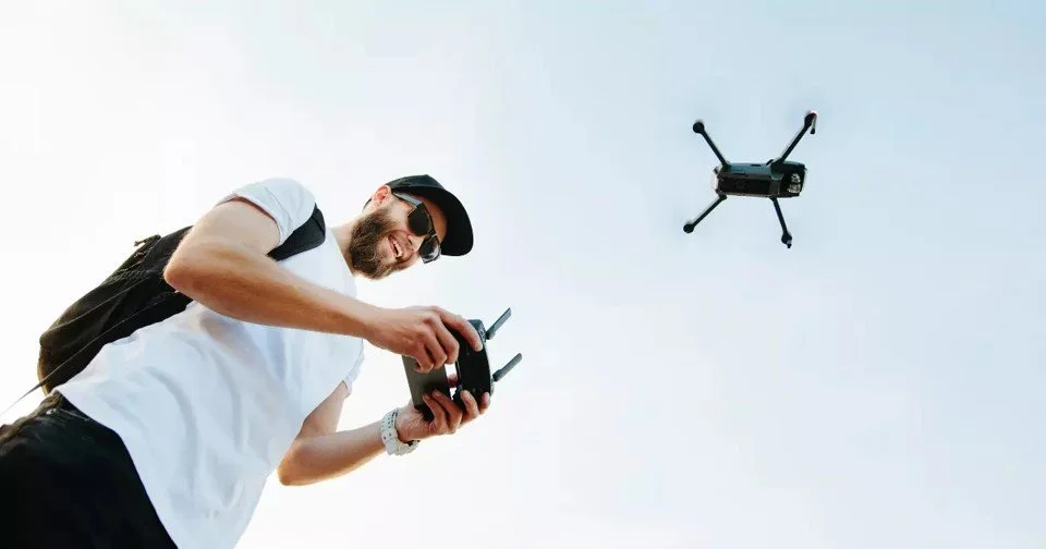
Drone Aerial Photography
Drone aerial photography uses small, unmanned aircraft to capture images from various heights. Drones allow for flexibility and access to hard-to-reach areas. They’re popular for real estate, events, and landscape shots. Drones provide high-resolution real estate photos at relatively low costs. Many drones can also capture video for dynamic visuals.
Read also: Is Real Estate Drone Photography the Game-Changer You Need?
Oblique Aerial Photography
Oblique aerial photography captures images at an angle, rather than from overhead. This angle gives photos depth and dimension, showing more of the landscape. It’s ideal for showcasing terrain or structures in context. Oblique imagery is often used in architecture and urban planning. They can reveal hidden details or highlights in a landscape.
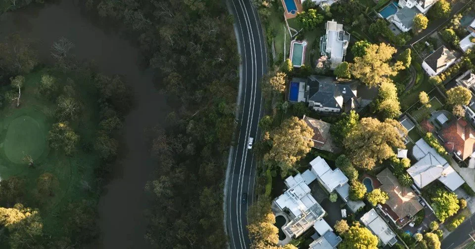
Vertical Aerial Photography
Vertical aerial photography involves capturing images directly overhead, pointing straight down. This style is perfect for maps and land surveys, providing an accurate, flat view of the area. Vertical photos capture large landscapes with precise detail. They’re commonly used in cartography and environmental studies. Vertical imagery helps in analyzing topography and land usage.
High-Altitude Aerial Photography
High-altitude aerial photography involves capturing images from airplanes or satellites at great heights. This type covers vast areas, often showing entire cities or regions. It’s used in meteorology and environmental monitoring. High-altitude shots help track large-scale changes in the earth’s surface. They’re essential for mapping and tracking climate change.
Low-Altitude Aerial Photography
Low-altitude aerial photography takes place closer to the ground, often below 1,000 feet. It captures more detailed images of specific sites, like buildings or small plots of land. This type is used in agriculture and real estate. Low-altitude shots highlight finer details in the landscape. They’re effective for capturing clear, close-up images.
Close-Range Aerial Photography
Close-range aerial photography is typically performed at distances less than 300 feet. This type captures detailed images, often of smaller areas or objects. It’s common in wildlife studies and event photography. Close-range photos provide high-resolution close-ups. They’re perfect for capturing specific features in high detail.
Infrared Aerial Photography
Infrared aerial photography uses infrared technology to capture images beyond the visible spectrum. It’s useful for detecting heat and vegetation health. This type reveals details not seen in regular light. Infrared photos are valuable in agriculture and environmental studies. They help in assessing plant health and water levels.
Thermal Aerial Photography
Thermal aerial photography captures heat patterns. It’s useful for identifying energy loss and warm areas. It’s commonly used in energy audits and rescue missions. Thermal images reveal temperature differences, showing hot or cold zones. They’re essential for monitoring wildlife and tracking industrial heat leaks. This type helps improve energy efficiency in buildings.
Panoramic Aerial Photography
Panoramic aerial photography stitches many images together for a wide, sweeping view. This type is ideal for landscapes, skylines, or large sites. Panoramic shots provide a full scene in a single image. They’re popular in tourism and event photography. Panoramic views highlight the vastness of an area, giving a sense of scale.
What are The Basic Skills Needed in Aerial Photography?
Aerial photography requires technical expertise, creativity, and a strong focus on safety. Photographers need a solid foundation to capture stunning images and ensure smooth operations.
Here are the essential skills every professional aerial photographer needs. You may also check out our comprehensive guide on real estate photography to learn more tips.
Understand Composition
A strong understanding of artistic photo composition is essential in aerial photography. Photographers frame subjects from above to create appealing images with natural color and detail. Taking photos from altitudes requires skillful use of angles, perspectives, and lighting. Both oblique and vertical shots benefit from careful composition. A well-composed aerial photo stands out.
The surrounding environment also plays a key role. In real estate photography, capturing the property layout and surroundings requires precision. This approach ensures aerial photos convey valuable information. It also makes them look professional and compelling.
Drone or Aircraft Operation Skills
Operating drones or aircraft efficiently is a key skill in aerial photography. Operators control flight paths, adjust altitude, and maneuver smoothly for stable aerial images. Pilots must navigate various conditions to capture quality shots from any height and distance.
For manned aircraft, communication between the photographer and the pilot is crucial. Photographers must direct the pilot to achieve the desired angles and camera positions. Understanding an aircraft’s limitations is essential for capturing optimal shots.
Knowledge of Legal and Regulatory Compliance
Compliance with legal standards is crucial in aerial photography. Drone pilots must understand airspace rules, no-fly zones, and permit requirements. Operating near airports or restricted areas without clearance can lead to penalties.
Privacy laws also apply, especially when photographing residential areas. Capturing aerial images legally and safely is essential. It helps maintain operational integrity and prevents legal issues.
Master Timing and Weather Conditions
Timing and weather are crucial in aerial photography. Knowing the ideal time to shoot, like the "golden hour," enhances digital imagery quality. Lighting and the level of haze shift throughout the day, affecting aerial image quality. Understanding these factors helps photographers achieve optimal results.
Weather also plays a major role. Windy conditions can destabilize drones, causing blurred or shaky shots. Overcast skies may reduce color vibrancy, impacting the original scale of the image. Photographers must assess weather conditions and adjust plans to capture clear, stable shots. This ensures quality digital imagery in any environment.
Attention to Safety Protocols
Safety is crucial in aerial photography. This is especially true when flying drones in crowded or obstacle-rich areas. Pilots must stay vigilant, keeping an eye out for hazards like power lines, trees, or buildings. Knowing how to execute emergency landings and avoid obstacles is essential for safe drone operation.
In manned aircraft, strict safety protocols must be followed during flight. Photographers working from aircraft must collaborate closely with pilots. This is to ensure that safety procedures are in place and adhered to at all times.
What are The Tools and Equipment in Aerial Photography?
Aerial photography relies on specialized tools to capture high-quality images from above. From drones to post-production software, it is vital to have the right equipment for professional results.
Here are the key tools and equipment every aerial photographer should have.
High-Resolution Camera
A high-resolution camera is crucial for capturing detailed and sharp images. Modern drones and aircraft usually have cameras that shoot in 4K or higher resolutions. This ensures that aerial photographs are crisp and clear, even when zooming in on specific areas.
For large-scale projects, or those needing fine detail, high-megapixel cameras are essential. They help maintain image quality and capture important details without loss.
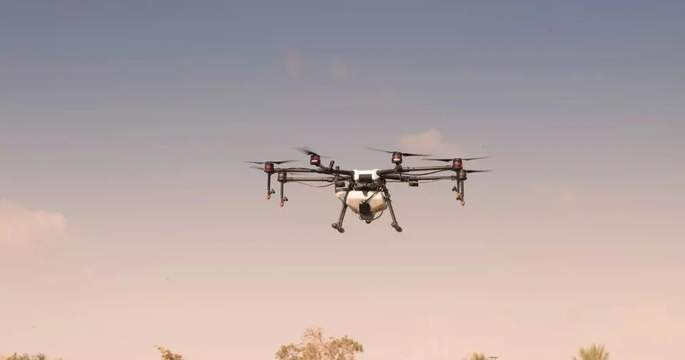
Drones with Advanced Stabilization Systems
Drones are a popular tool in aerial photography because of their flexibility and ease of use. Advanced stabilization systems, such as 3-axis gimbals, help keep the camera steady, even in windy conditions. This prevents shaky footage and ensures smooth, stable video or still shots.
Drones with these systems can capture high-quality aerial imagery, minimizing blur or distortion.
Flight Planning Software with GPS Integration
Flight planning software integrated with GPS is essential for precise aerial photography. This software allows photographers to map specific flight paths. It ensures they cover the desired areas efficiently.
GPS-guided drones can follow pre-programmed routes, making them ideal for precise mapping. This enables consistent results, making it ideal for tracking progress over time.
Fixed-Wing Aircraft for Large-Scale Projects
For larger projects that cover extensive areas, fixed-wing aircraft are more efficient than drones. These aircraft can fly at higher altitudes and cover more ground in a single flight.
Fixed-wing aircraft are more expensive to operate. However, they are ideal for large-scale projects like agricultural surveys or environmental monitoring. They allow for the capture of wide-area aerial photographs quickly and efficiently.
Post-Production and Editing Software
Post-production is a vital part of aerial photography. After capturing images, photographers use editing software like Adobe Photoshop or Lightroom. These tools help enhance visuals by adjusting exposure, contrast, and color balance. The result is polished and professional images.
For video, software like Adobe Premiere Pro is essential. It smooths transitions, adds color grading, and refines overall quality. Post-production ensures that aerial imagery meets high standards.
Spare Batteries and Storage Devices
Long aerial photography sessions need spare batteries to keep the drone in the air for extended periods. Having extra batteries on hand ensures photographers don’t miss key moments due to a drained battery.
Additionally, high-resolution aerial images and videos take up a lot of storage space. Large-capacity storage devices, such as SD cards or portable hard drives, are essential for storing large amounts of data. This lets photographers capture high-resolution images without running out of space.
How Can Professional Aerial Photography Benefit Real Estate and Other Industries?
Professional aerial photography enhances how a real estate photography business showcases properties and projects. Detailed images from above provide unique perspectives that traditional photography can’t match. This approach displays vast spaces and highlights key features. These qualities make aerial photography valuable for real estate, construction, and urban planning.
Below are the key ways aerial photography benefits these sectors.
Showcase Property Layouts and Land
One advantage of aerial photography in real estate is its ability to capture an entire property in a single shot. Ground-level images often fall short for large estates, commercial developments, or rural land. They simply can’t show the true scale and layout. Aerial photographs taken from higher altitudes offer a clear view of property boundaries. They also show building locations and how the land is used.
For instance, a real estate agent marketing a 10-acre property can use aerial images to showcase the landscape. These images can also highlight garden areas, parking lots, and building structures. This approach helps buyers fully understand the property’s scope.
In agriculture, aerial photography offers an effective way to survey large farmland areas. It gives a detailed view of crop layouts and field organization.
Professionals use oblique images to add depth or vertical shots to capture clear, top-down views for best results.
Highlight Proximity to Key Amenities
A key selling point in real estate is location and accessibility to local amenities. This includes schools, parks, shopping centers, and public transportation. Aerial photography allows businesses to capture this proximity from above. It provides potential buyers with a complete view of the neighborhood. Aerial images show how a property fits into its surroundings. This offers valuable context that ground-level shots cannot provide.
For example, an aerial photograph of a residential property can include nearby parks, schools, and shopping areas. This highlights how conveniently located the home is. Such context adds significant value. It allows buyers to see the surrounding infrastructure and environment at a glance. Aerial images also showcase aesthetic features that enhance the property's appeal.
Commercial properties benefit similarly from aerial photography. These images can emphasize foot traffic patterns, transportation hubs, and parking accessibility. This context helps investors make informed decisions about the location's viability. The right photo distance is also important. It helps capture these key details effectively.
Elevate Luxury Property Listings
For high-end or luxury real estate, professional aerial photography adds sophistication. It enhances marketing materials significantly. Luxury properties often feature expansive grounds, intricate landscaping, pools, and unique architectural elements. These details are difficult to capture fully from the ground. Aerial views showcase the scale, beauty, and exclusivity of these homes.
Read also: How to Create Captivating Photos for Real Estate Listings
For example, aerial images can show sprawling waterfront estates with gardens and outdoor living areas. These images highlight the property’s proximity to the water and its size. They also showcase high-end features, such as tennis courts or private docks. By incorporating aerial photography, luxury listings stand out. This approach offers a level of detail and grandeur that standard photography alone cannot achieve.
Enhance Marketing Materials with Aerial Photography
In real estate and other industries, aerial photography is essential for compelling marketing. Aerial photographs are used in brochures, online listings, and promotional videos. They capture attention with their dynamic and engaging perspectives. They show expansive overviews, unique angles, and detailed layouts. This makes aerial imagery a powerful tool for branding and marketing.
For example, real estate developers can use aerial images to showcase new housing developments. These images highlight infrastructure, neighborhood layouts, and available lots. In construction, aerial images provide visual updates on project progress. They allow stakeholders to see the entire site and identify key milestones.
In tourism, aerial photography highlights scenic views, nearby attractions, and property size. Using professional aerial imagery ensures that marketing materials stand out. It also helps them resonate with potential clients or customers.
Expertise in Photography and Framing
The expertise of a professional photographer is critical for capturing the perfect aerial image. Professionals have a deep understanding of composition, framing, and lighting. These skills are necessary to create impactful images. Aerial photography requires different techniques than traditional photography. This is due to the unique angles and perspectives involved.
Professionals know how to frame shots to highlight specific features. This includes the layout of a building or the surrounding landscape. They understand how to use both oblique and vertical photographs effectively. For example, an oblique photograph captures a building’s façade and landscape from an angle, providing depth and context. In contrast, a vertical photograph is ideal for clear, top-down views of a project or property.
This expertise ensures that the final aerial photographs are visually compelling and informative.
Safety and Legal Compliance
Operating drones or aircraft for aerial photography involves strict safety and legal considerations. Professional photographers are trained to operate within legal boundaries. They adhere to local and national regulations regarding airspace, no-fly zones, and privacy laws. For instance, in urban areas, operating a drone without the necessary permits can lead to legal issues.
Professionals ensure they have the appropriate certifications and licenses for aerial shoots. They follow established safety protocols to avoid potential hazards. These hazards include buildings, power lines, and crowded areas. This expertise helps prevent accidents. It ensures that aerial photography sessions run smoothly, without legal or safety risks.
For businesses, working with certified professionals provides peace of mind. They can be confident that all regulatory and safety standards are met.
Advanced Equipment and Technology Used by Professionals
One of the key benefits of hiring a professional for aerial photography is access to advanced equipment and technology. Professionals use high-resolution cameras and drones with advanced stabilization systems. They also utilize post-production software to deliver high-quality results.
For example, drones equipped with 4K cameras capture incredibly detailed aerial images. Stabilization systems ensure that the footage is smooth and free from shakiness.
Post-production tools like Adobe Photoshop or Lightroom enable photographers to enhance colors. They also allow photographers to adjust lighting. They can sharpen images, bringing the image to life and highlighting artistic elements. This ensures the final product is polished and professional.
How to Choose The Right Professional for Aerial Photography
When choosing the right professional for aerial photography, start by reviewing their portfolio. Verify their experience in your industry. A skilled photographer should have expertise in capturing various types of shots. This includes oblique and vertical photographs. They should also have experience with projects similar to yours.
It's important to ensure they are licensed and certified to operate drones or other equipment legally. They must be familiar with local airspace regulations. Understanding safety protocols is crucial to avoid any legal issues.
Beyond experience, discuss the equipment they use. Make sure it meets your project’s needs. High-resolution cameras, advanced drones with GPS, and professional editing software are essential. These tools are necessary for capturing sharp, high-quality aerial images.
Additionally, clear communication is key. Discuss your project’s goals and expectations with the photographer. This helps them understand your vision. It also allows them to offer helpful recommendations.
Lastly, compare pricing and services. Ensure the cost aligns with the quality and scope of the work provided.
Wrapping Up
Aerial photography offers a unique perspective that standard photography cannot achieve. It brings projects to life with stunning visuals. Aerial photography showcases property layouts and highlights nearby amenities. It also boosts the marketability of luxury listings. Aerial photography captures the full scope of a property. This enables informed decision-making and effective marketing.
Are you ready to elevate your project? Denver Real Estate Photography offers professional photography services tailored to your needs. With state-of-the-art equipment and a skilled team, we deliver high-quality visuals. Our goal is to showcase your project effectively.
Our expertise in framing, safety, and technology makes us the best choice for your aerial photography needs. Contact us today at (720) 443-1724 to see how we can help elevate your marketing and visuals!
from Blog - Denver Real Estate Photography https://www.denverrealestatephotography.com/blog/aerial-photography
via Denver Real Estate Photography

Comments
Post a Comment